


Unlocking the Subsurface: Building Spatial Reasoning Skills and Models with Visible Geology
- Oct 5, 2025
- 4 min read
Our Earth is three-dimensional (3D), sorry "Flat Earthers". There is an inherent challenge in teaching #D processes in a two-dimensional (2D) classroom with flat media like whiteboards, textbooks, and diagrams. The geosciences require students to be able to synthesize 1D or 2D representations like a topographic map, cross section, or data plots and use them to construct an integrated and dynamic 3D mental model of the Earth, its subsurface structures, landforms, and processes. Students who lack highly developed spatial visualization or penetrative thinking skills will struggle with this translation. That’s where Visible Geology comes in. This free, interactive simulator allows students to build, slice, and analyze virtual rock layers and geologic structures, giving them a hands-on way to explore Earth’s dynamic history. In this post, I’ll show how I use Visible Geology in my classroom to develop students’ spatial reasoning skills, reinforce NGSS model-building practices, and integrate interactive labs and guided resources that make geologic concepts come alive.
Why Spatial Reasoning Matters
Key geoscience tasks, such as interpreting geological block diagrams or predicting the shape of rock layers beneath the surface, require the ability to mentally rotate, dis-embed, and transform objects, which many students find difficult. Then you bring in the vastness of scale and time, and you have another dimension of confusion for students. Many critical Earth processes (e.g., plate tectonics, global atmospheric circulation, ocean currents) occur at spatial scales that span thousands of kilometers, making them impossible to observe or replicate in a classroom. Students' understanding is strongest for things near human size and weakens significantly as the scale becomes vast. Authentic phenomena can't be brought into the classroom; instruction often relies on analog models (like a convection tank for ocean currents or a sand layer box for folding). The challenge is that students often focus on learning about the analog model itself rather than making the crucial, difficult leap of analogical reasoning to the full-scale, abstract Earth system it represents.
Many core concepts in Earth Science, such as the flow of magma, the movement of groundwater, or the internal structure of the planet, are hidden beneath the surface. Two-dimensional drawings often fail to communicate the connectivity and continuity of these internal features, leading to common misconceptions (e.g., students failing to realize that the inside of a geological block diagram is not the same as the surfaces they see). Unlike fields where students can often manipulate the actual phenomenon (like a chemical reaction), Earth scientists primarily rely on indirect data (seismic waves, remote sensing) to infer 3D structure. Teaching students how to use 1D/2D data to build a 3D model is a significantly different and more complex type of inquiry than traditional lab-based experimentation. Traditional classroom resources (diagrams, textbooks, posters) are static and two-dimensional, forcing students to use their own unevenly developed spatial skills to infer the dynamic, three-dimensional movement and configuration of Earth's systems. While field trips are the ultimate 3D learning experience, they are limited by logistical, safety, and time constraints, leaving the classroom as the primary, yet poorly suited, environment for developing crucial spatial understanding.
What Visible Geology Offers
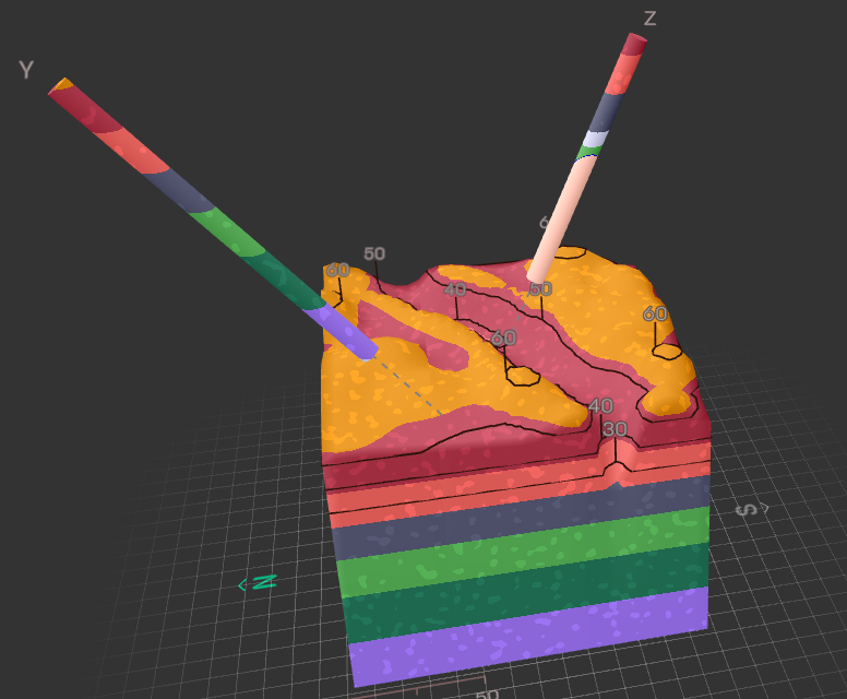
Visible Geology is a free interactive 3D geological modeling simulator. Students build 3D geological models of sedimentary layers, intrusions, faults, folds, unconformities, and volcanic features. and more. The program can cut cross-sections, rotate, and analyze rock formations as well as view core samples of the matter and investigate strike and dip of the bedding planes. The stereonet and apparent dip tools are excellent for undergraduate Structural Geology courses as well as professional geologists working in the private sector. The program supports inquiry-based learning and hands-on experimentation without lab materials. One of the key features I am currently enamored with is the ability to create your own topography. This feature greatly expands the usability of the product and allows for extension and enrichment projects as well as to be able to build customized landscapes. There are a few pre-built models, such as Mount St. Helens and The Grand Canyon, which can be used to compare to student models or to supplement existing activities in your classroom.
How I built my NGSS-Aligned Visible Geology Activities
This weekend, I put together three labs for my high school classes using Visible Geology. Each lab kicks off with a bell ringer and wraps up with exit tickets. I've also included a guided informational text assignment with annotations to help with learning. Plus, there are teacher keys and summary sheets. For two of the labs, I've added Claim Evidence Reasoning Activities. My main goal was to blend 3D modeling with writing and analysis skills. Student outcomes include increased ability to visualize complex geologic structures in 3D. Students will have an improved understanding of relative dating, cross-cutting relationships, and rock cycles. Finally, students will practice with scientific reasoning, data analysis, and evidence-based explanation.

Visit my Teachers Pay Teachers Store for these resources. Geologic Modeling - an Introductory lab that dives into the overall features students build geologic sequences, identify cross-cutting relationships, and write CERs.
Reading the Rock Record Lab — students build geologic sequences, focus on geologic time, and compare models to the pre-built model of the Grand Canyon
Modeling Magma - Igneous Intrusions Lab — modeling magma chambers, dikes, sills, lava flows, and contact metamorphism. Students compare their model to the pre-built model of Mount St. Helens
All Three Bundled together!
Tips for Using Visible Geology in Your Classroom
Start with simple layering exercises before adding intrusions or faults. Allow students time to play with the model and build various models. Encourage collaboration and discussion when constructing geologic histories. Use the Mount St. Helens and the Grand Canyon models or other prebuilt examples to connect simulations to real-world events. Finally, scaffold CER writing and guided analysis for less confident students.
Using Visible Geology in the classroom transforms abstract geologic concepts into hands-on, visual experiences that engage students and deepen understanding. By building and analyzing their own rock models, comparing them to real-world examples like Mount St. Helens, and completing guided CERs, students strengthen their spatial reasoning, scientific thinking, and NGSS modeling skills. Whether you’re teaching intrusive igneous features, sedimentary layering, or volcanic terrains, these interactive labs and accompanying resources provide a ready-made, NGSS-aligned pathway to make Earth Science both accessible and exciting. Give it a try, and watch your students start to see Earth in three dimensions—literally!
Comments